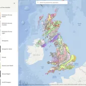
Bluesky Mapshop now serving BGS data

Agreement sees range of geological and geohazard map layers made available online
AN agreement between the British Geological Survey (BGS) and aerial mapping company Bluesky is allowing for a range of geological and geohazard map layers to be made available online at blueskymapshop.com
The eight new layers cover a variety of physical features and hazards, including a nationwide map of groundwater flooding as well as ground stability data, geological indicators of flooding and permeability data.
Widely used by developers, planners, environmental consultants etc, this new data complements the national datasets already on offer, including high-resolution aerial photography, detailed height models and Ordnance Survey mapping.
‘These datasets are important tools for those making decisions about new developments, including analysis of flood prediction, prevention and management,’ commented Bluesky’s managing director, Rachel Tidmarsh.
‘They complement data already on offer, including height models, a recently launched flood risk map and our range of free data, which includes other data from BGS as well as English Heritage, Natural England and the Environment Agency.’
Among the new layers, five new map products relating to groundwater are available, including the first national hazard dataset for groundwater flooding. Based on geological and hydrogeological information, the 1:50,000-scale digital data can be used to identify areas where geological conditions could allow groundwater flooding to occur, and where groundwater may come close to the ground surface.
In addition, Geological Indicators of Flooding shows areas vulnerable to both inland and coastal flooding identified from the geological deposits present. Also available is: an Aquifer Designation Map identifying different types of aquifers across England and Wales, and reflecting the importance of aquifers in terms of groundwater as a resource; an Infiltration SuDS (Sustainable Drainage Systems) map; Permeability Data; and the WellMaster Hydrogeological Database.
The geological map layers from BGS that are now available through the Bluesky Mapshop include both the 1:10,000 scale and 1:50,000 scale DigMapGB digital geological maps of Great Britain. These cover five standard themes: Artificial Ground, Bedrock Geology, Linear Features, Mass Movement Deposits and Superficial Deposits, as well as a composition type.


