The role of drones in monitoring and managing biodiversity
First published in the March 2025 issue of Quarry Management
By Simon Briggs, managing director, Geodime Ltd
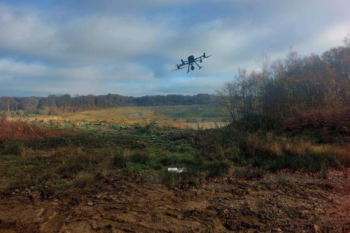
The drone industry has seen huge leaps in technological progression in recent years with sensors which were previously only carried by manned aircraft now carried by drones. This means that undertaking remote sensing for conservation and biodiversity projects is currently more accessible than ever.
Biodiversity initiatives and Biodiversity Net-Gain
Successful conservation management of quarries plays a crucial role in the local biodiversity and ecological make-up of an area. Both an active quarry and subsequent restored land can become a haven for wildlife and spaces where native plants can thrive. Proactively managed areas have far-reaching benefits and the need to protect and enhance biodiversity is well recognized. Initiatives such as the Heidelberg Materials ‘Quarry Life Awards’ and the MPA ‘Restoration Awards’ and ‘Biodiversity Awards’ seek to encourage scientific and innovative approaches to conservation and biodiversity management, and these initiatives are not confined to the borders of a site but also encourage improvements to the neighbouring environment.
Additionally, Biodiversity Net Gain (BNG) is a mandatory planning requirement which determines that habitat loss as the result of development must be addressed and measures must be taken to ensure that a project either implements biodiversity improvements on site or funds improvements elsewhere. Quantifying and managing BNG is a complex issue and approaches to improving biodiversity must be considered on a site-by-site basis. Typically, BNG is measured using standardized ‘biodiversity units’ and these units are calculated using a formula of combined factors. Improvements to a site’s biodiversity can only be accurately demonstrated following a detailed baseline assessment and subsequent monitoring surveys, and this is where drones can play a key role.
Multispectral imagery
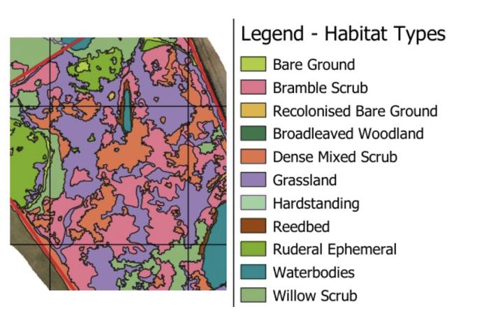
Multispectral cameras capture light wavelengths beyond the natural capabilities of the human eye. Different materials absorb, reflect, and emit different spectral signatures. These signatures can be analysed to classify different vegetation types and, therefore, inform habitat area. Red, green, blue (RGB) imagery (standard photography) contains only subtle colour differences between vegetation types, whereas multispectral imagery contains a much greater range and is more differentiated and, therefore, more suitable for analysis. Satellite imagery contains multispectral data and is useful for habitat mapping on a broad scale, which can help to inform landscape connectivity, putting the quarry site in context with the surrounding landscape. However, drone-based multispectral data provide us with far higher-resolution imagery which allows for more refined and detailed analysis of a study area (see fig. 1).
Drones also make the task of monitoring changes over time accessible. Georeferenced surveys taken during the life of the quarry can be overlaid and directly compared with earlier surveys, allowing us to draw well-informed conclusions as to changes over time. This makes them a powerful tool for such analysis as the development of scrub (widely recognized as a high-value habitat type) to larger whole-site analysis to calculate biomass change over time.
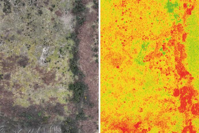
Vegetation stress is calculated by comparing the values from the near-infrared band with the red band. The results of this calculation is called the normalized difference vegetation index (NDVI) and is a great indicator of plant health. The agricultural sector regularly uses NDVI data to identify areas of crop stress and to allow targeted fertilizer application.
Figure 2 Shows an aerial view of an area of vegetation taken using standard RGB photography. Figure 3 shows the same view taken with a multispectral sensor displaying the NDVI values of the image. Healthy vegetation is shown as dark red, and unhealthy (or unvegetated areas) are displayed in green.
Thermal imagery
Thermal sensors are also a useful tool for assessing vegetation health. Generally, the warmer an object is, the more thermal radiation is emitted. Stressed vegetation can be identified from its thermal output; a diseased plant will have an altered thermal output compared with its healthy neighbour. A combined approach that uses thermal data alongside multispectral analysis can help us to target diseased or dead vegetation. This is a particularly valuable tool when considering the current issues faced in UK woodlands due to ash dieback. Remote sensing techniques can be used to quickly identify diseased and dead trees, reducing the need for manual surveys.
LiDAR
Drone-based photogrammetry is a great tool for modelling ground where the earth is bare. LiDAR is typically used to strip out vegetation and show the topography beneath. Photogrammetry simply cannot do this. LiDAR also collects data from laser returns off vegetation as well as returns from the ground, enabling the 3D modelling of trees and scrub.
LiDAR also detects intensity values from features it scans. These values directly relate to the way a material reflects light. It can, therefore, also be analysed in a similar way to multispectral imaging and has the potential to distinguish different tree types.
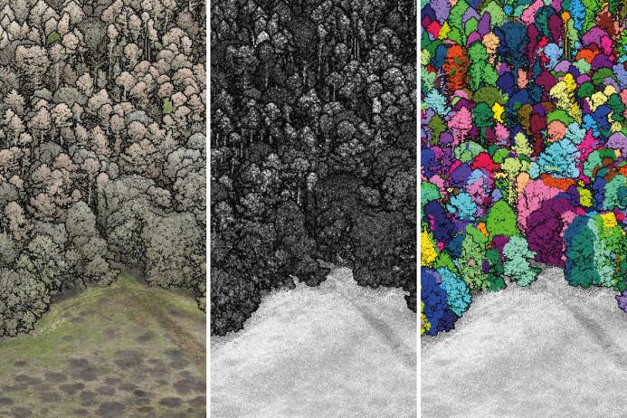
LiDAR data can be classified and queried in numerous ways, to provide us with detailed vegetation metrics, and help to identify different habitat areas and assist in woodland management. In most cases, LiDAR can be used effectively to estimate tree counts, individual tree heights, canopy extents, and sometimes the location and size of trunks. It is a powerful tool for the capture of BNG baseline data and change management.
The future
Georeferenced multispectral, thermal, and LiDAR are powerful datasets, particularly when analysed in combination. Accurate, comprehensive and detailed ecological baseline data is the essential starting point for future monitoring and informed management. The accessibility of drones and the ability to use these sensors with relative ease means that remote sensing can be timed to ensure a consistency of variables, working around seasonal effects. Drones are a very cost-effective means of capturing complex data over large areas on demand. Currently, the extraction and analysis of that data is complicated, but exciting innovations in AI and machine learning are enhancing our ability to analyse such information.
Subscribe to Quarry Management, the monthly journal for the mineral products industry, to read articles before they appear on Agg-Net.com


