Kelso Quarry Park
From working quarry to public conservation area in Ontario’s Greenbelt
By Sarah Lowe and Sherry Yundt
The former Milton Limestone Quarry near the town of Milton, in the region of Halton, is on the edge of the province of Ontario’s major population centre – Greater Toronto. The quarry opened in 1958, together with others in the local area, to provide construction materials to build the new provincial Highway 401.
The quarry’s strategic location near to Toronto has made it an excellent site for supplying aggregates to Canada’s largest market. It is situated on the physiographical feature known as the Milton Outlier, on the Niagara Escarpment, which represents a prime source of high-quality Silurian Amabel dolostone. Milton Limestone Quarry supplied 1 million tonnes of crushed stone annually for construction uses for over 40 years until operations ended in 2001 (fig. 1).
The strategic location of the site also makes the rehabilitated quarry a prime candidate for public use. Not only is it less than 50km, on provincial highways, from downtown Toronto and Hamilton, it is situated in a scenic and biodiverse natural area of the Niagara Escarpment. Nearby, more than 1,000ha are already in public ownership and visited by thousands of residents and tourists each year for the purposes of skiing, hiking, rock climbing, swimming, boating or outdoor education.
The site itself lies within the Niagara Escarpment Plan area, within the province’s Greenbelt (fig. 2), an area of more than 700,000ha of green space that the province established in 2005 to preserve the natural resources from urban development.
Lands adjacent to the site are owned by Conservation Halton, a local environmental agency that operates on a watershed basis. A major function of such conservation authorities is protection of watersheds through ownership and management of lands that are also used for public education and recreation. One such public park is the Kelso-Glen Eden Conservation Area, which is immediately adjacent to the former Milton Limestone Quarry. This park includes a major skiing area, extensive trails above the escarpment and a reservoir (Lake Kelso). While the main function of the reservoir is flood control and stream flow augmentation, it is also a major recreation facility for swimming and boating.
Milton Limestone Quarry’s active life as a fully operational site was followed by a second phase spanning a period of 10 years when the final rock was recovered during site rehabilitation. The quarry was finally donated to the conservation authority in August 2006 and is now starting its new life as a public conservation and recreation area. It joins several other former quarries in the region of Halton that contribute natural heritage and recreation values as public parks (Zimmerman and Lowe 2006).
Visionary public-private partnership
As the quarry approached the end of its working life in the mid-1990s, Conservation Halton recognized the potential value of the site as an addition to its existing Kelso-Glen Eden Conservation Area. They negotiated with the owners, Barrick Gold Corp., to donate it when fully extracted and rehabilitated. Lands donated include the rehabilitated quarry and an adjacent 700m swathe of natural forest and cliffs that had been protected from extraction within the 71ha licensed area.
The natural forest and cliffs are ecologically significant and will be protected in a special nature reserve zone under the master plan to be completed by Conservation Halton. The University of Guelph’s Cliff Ecology Group discovered an old-growth forest of eastern white cedar within this zone in the mid-1990s, and Nature Conservancy of Canada has expressed interest in helping to provide support to protect this ecosystem.
An innovative part of the agreement between Conservation Halton and Barrick Gold was to refine the final rehabilitation plan to accommodate Conservation Halton’s wishes for a recreational lake, while remaining consistent with the requirements in the site plans approved under the Aggregate Resources Act.
Protecting ecosystems and allowing for future public use
The quarry itself had been progressively rehabilitated since the 1970s, with the east cliffs sloped and planted with grasses and thousands of native trees. However, the main rehabilitation activity took place in the last 10 years, as the limits of the property were reached. The approved rehabilitation plan included provision for a 5m deep lake in part of the quarry floor and identified recreation as a possible after-use.
The rehabilitation was particularly innovative both in the approach to cliff and slope creation to produce varied landforms, and in the configuration of the lake in the quarry floor to make it suitable for a public recreation area.
Initially, the quarry faces were backfilled conventionally from top to bottom in 2:1 and 3:1 slopes as per legislation, using native soil and imported clean fill. These slopes provide linkage to the abutting natural areas. However, when more recent extraction was completed along the final (west) face, a different approach was used. The quarry face was left as a cliff rather than being backfilled.
An attempt was made in the late 1990s to perform a ‘restoration blast’ where the blast action itself would produce the final rehabilitated landform. The aim was to establish a ledge that could be re-vegetated half way down the 25–30m high face. Unfortunately, although the blast was carefully designed and executed, it was not totally successful. The shot rock did not clear the ledge and left an unstable surface of loose rock that had to be scaled. However, for aesthetic purposes, the upper cliff face was left exposed at the top with only the bottom two-thirds backfilled. The resulting cliffs are compatible with the surrounding natural cliff landscape and are accepted by the regulating agencies as a valid form of rehabilitation in this scenic location.
A detailed rehabilitation plan designed by staff at Conservation Halton guided the final extraction of the quarry floor. The lower few metres of the Amabel Formation, and some of the underlying Reynales Formation, were extracted to recover the last remaining bedrock resource and create the final lake configuration (fig. 3). The lake design included shallow areas and shoals for fish habitats, and also areas for future public beaches. Lake levels, which were determined as part of a hydrogeological study, are managed by a small weir structure (fig. 4a &b), allowing gravity outflow for the spring freshet or storm water events into a defined open channel, which then flows through a buried drainage channel that eventually surfaces at the edge of the escarpment.
Instrumental in carrying out the rehabilitation plan was former quarry manager, the late Bill Scott, who passed away in 2006. He took on the task of a much more elaborate rehabilitation program than normal and, in addition to carrying out the company’s and Conservation Halton’s directions, also provided his own personal touch to the quarry rehabilitation, including the placement of large boulders alongside the lake (fig. 5).
Over the years the company used several grass and legume mixtures to stabilize the slopes and quarry floor, and planted native trees on the slopes. A list of the grass mixtures and trees planted is shown in table 1.
As a result of the outstanding success of the final rehabilitation, in 2007 the Ontario Stone, Sand and Gravel Association (OSSGA) awarded Barrick Gold the prestigious Outstanding Achievement in Property Rehabilitation Award (fig. 6).
Already a public asset
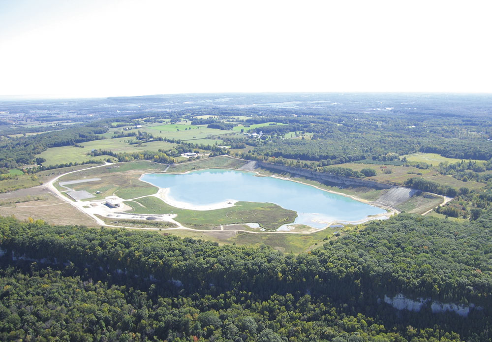
Today the site is an exceptionally beautiful property set within the surrounding natural area of the Niagara Escarpment (Fig. 7).
The property is not yet open to the public, although Conservation Halton does have trails that run along the western edge of the site allowing scenic views across the property. These trails also connect to the Bruce Trail, an 845km public hiking trail that runs along the Niagara Escarpment from Niagara Falls to Tobermory.
Since taking ownership in 2006, Conservation Halton has completed soil and groundwater site remediation around the former workshop area, and has carried out tree planting for two years as part of their Trees for Watershed Health Program (fig. 8). Wildlife is already beginning to use the rehabilitated areas of the quarry (fig. 9).
The role of the former quarry site as part of the Kelso-Glen Eden Conservation Area will be further evaluated as the 2002 Kelso master plan and the Niagara Escarpment Plan are updated. This review will include biological inventories of the property so that land use designations can allow for active public use, as well as protecting the valuable natural ecosystem along the edge of the escarpment.
In autumn 2008, Conservation Halton held a public dedication ceremony to celebrate the start of Kelso Quarry Park’s new role as a public asset. This event was used to launch fundraising efforts to implement the installation of park infrastructure and facilities befitting this spectacular regional escarpment park.
Acknowledgements
The authors would like to thank staff at Conservation Halton for their assistance with this article and for providing figure 8.
References
- Conservation Halton, Halton Hikes - 50 Great Hiking Trails, 2007.
- Conservation Halton, Master Plan, 2002.
- Conservation Halton, Viewpoint Quarry Expansion and Rehabilitation, 2008
- S.E. Yundt Ltd, Outstanding Achievement in Property Rehabilitation Award, APAO Milton Limestone, 2004.
- ZIMMERMAN, K., and S. LOWE: ‘Rehabilitated Quarries provide a public asset in the Greenbelt’, NEC Leading Edge Conference, 2006.
This article was first published in Canadian Reclamation, Issue 2, Fall/Winter 2008 (published on behalf of the Canadian Land Reclamation Association [CLRA/ACRSD]) and is reprinted here by kind permission of the CLRA/ACRSD and Aquila Publishing.
